Hurricane Tracking 2012

Page 3 of 18 FirstFirst 1234513 ... LastLast

  1. Posts : 2,686
    Windows 8.1 Pro w/Media Center 64bit, Windows 7 HP 64bit
    Thread Starter
       #21

    After no Atlantic activity for over a Month we have a bite.

    Hurricane Tracking 2012-td-5.png

    Jim
      My Computer


  2. Posts : 2,686
    Windows 8.1 Pro w/Media Center 64bit, Windows 7 HP 64bit
    Thread Starter
       #22

    5PM Aug 2 Update


    He is now TS Ernesto with 50mph winds.

    Hurricane Tracking 2012-ernesto-01.png

    Jim
      My Computer


  3. Posts : 2,686
    Windows 8.1 Pro w/Media Center 64bit, Windows 7 HP 64bit
    Thread Starter
       #23

    5PM Aug 4 Update


    Ernesto heading to the Yucatan and into the Gulf.

    Hurricane Tracking 2012-ernesto-02.png

    Florence in Eastern Atlantic and may die as it turns North/West in 5 days.

    Hurricane Tracking 2012-florence.png

    Jim
      My Computer


  4. Posts : 2,686
    Windows 8.1 Pro w/Media Center 64bit, Windows 7 HP 64bit
    Thread Starter
       #24

    Mon 2pm update


    As predicted Florence has died off into a sub-tropical low.

    Ernesto is heading to Mexico-Belize border and may reach 90mph winds before landfall on Wed.

    Hurricane Tracking 2012-ernesto-03.png

    Jim
      My Computer


  5. Posts : 2,686
    Windows 8.1 Pro w/Media Center 64bit, Windows 7 HP 64bit
    Thread Starter
       #25

    Ernesto Landfall


    At 1000 pm cdt...0300 utc...data from the Belize radar indicate hurricane Ernesto made landfall along the southern coast of the Yucatan peninsula near Mahahual Mexico as a category 1 hurricane.

    Summary of 1000 pm cdt...0300 utc...information

    location...18.7n 87.7w about 0 mi...0 km E of Mahahual Mexico about 40 mi...65 km ENE of Chetumal Mexico
    maximum sustained winds...85 mph...140 km/h
    present movement...w or 270 degrees at 15 mph...24 km/h
    minimum central pressure...980 mb...28.94 inches

    Jim
      My Computer


  6. Posts : 2,686
    Windows 8.1 Pro w/Media Center 64bit, Windows 7 HP 64bit
    Thread Starter
       #26

    4pm wed Aug 8


    Ernesto:

    THE CENTER WILL MOVE OVER THE EXTREME SOUTHERN BAY OF CAMPECHE TONIGHT AND EARLY THURSDAY...AND BE NEAR OR OVER THE GULF COAST OF MEXICO IN THE HURRICANE WATCH AREA LATER ON THURSDAY. MAXIMUM SUSTAINED WINDS ARE NEAR 50 MPH...85 KM/H...WITH HIGHER GUSTS. SOME STRENGTHENING IS FORECAST TONIGHT AND EARLY THURSDAY. WEAKENING IS EXPECTED AFTER THE CENTER MOVES OVER LAND LATER ON THURSDAY.
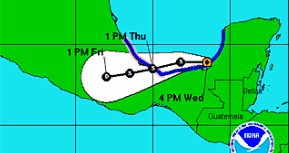
    Hurricane Tracking 2012-ernesto-4.png

    Jim
      My Computer


  7. Posts : 4,751
    Windows 7 Home Premium 32-Bit - Build 7600 SP1
       #27

    I really like your Hurricane tracking. Keep it up.
      My Computer


  8. Posts : 2,686
    Windows 8.1 Pro w/Media Center 64bit, Windows 7 HP 64bit
    Thread Starter
       #28

    10pm Thur Aug 9


    A new one to watch.

    Hurricane Tracking 2012-td7.png

    Jim
      My Computer


  9. Posts : 2,686
    Windows 8.1 Pro w/Media Center 64bit, Windows 7 HP 64bit
    Thread Starter
       #29

    Sat 11am update


    TD 7 from my previous post has dissipated into a wave but the NHC will monitor it for any new development.

    THE WAVE CONTINUES TO MOVE RAPIDLY TO THE WEST AT AN ESTIMATED SPEED OF 22 KT. THE AXIS OF THE WAVE SHOULD MOVE ACROSS THE LESSER ANTILLES THIS EVENING AND THEN CONTINUE WESTWARD ACROSS THE CARIBBEAN SEA DURING THE NEXT FEW DAYS. HEAVY RAINS AND WIND GUSTS TO TROPICAL STORM FORCE ARE STILL POSSIBLE ACROSS PORTIONS OF THE LESSER ANTILLES LATER TODAY AND TONIGHT.
    Also Ernesto has crossed into the Pacific and is reforming but is heading west out to sea and may dissipate in 5 days.

    Jim
      My Computer


  10. Posts : 2,686
    Windows 8.1 Pro w/Media Center 64bit, Windows 7 HP 64bit
    Thread Starter
       #30

    11am 8/21 New TD


    A new tropical disturbance has formed.

    Hurricane Tracking 2012-td-9.png

    Hurricane Tracking 2012-td-9-satalite.png

    Jim
      My Computer


Page 3 of 18 FirstFirst 1234513 ... LastLast

  Related Discussions
Our Sites
Site Links
About Us
Windows 7 Forums is an independent web site and has not been authorized, sponsored, or otherwise approved by Microsoft Corporation. "Windows 7" and related materials are trademarks of Microsoft Corp.

© Designer Media Ltd
All times are GMT -5. The time now is 04:36.
Find Us